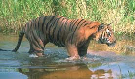
Periyar is a protected area, and a nature reserve in the South Indian State of Kerala, set high in the mountains of the Western Ghats at the border to Tamil Nadu. It lies in the districts of Idukki and Pathanamthitta. The protected area covers an area of 777 km², out of which a 350 km² part of the core zone was made into the Periyar National Park and Tiger Reserve, sometimes dubbed the Periyar Wildlife Sanctuary. The park is often called by the name thekkady also. Thekkady is located four km from Kumily, approximately 100 km east of Alappuzha, 110 km west of Madurai and 120 km southeast from Kochi.
Geography
The Periyar protected area lies in the middle of a mountainous area of the Cardamom Hills. In the north and the east it is bounded by mountain ridges of over 1700 metres altitude and toward the west it expands into a 1200 meter high plateau. From this level the altitude drops steeply to the deepest point of the reserve, the 100 meter valley of the Pamba River. The highest peak is the 2019 meter high Kottamalai.
The sanctuary surrounds picturesque 26 km² Periyar lake, formed by the building of Mullaperiyar Dam in 1895. This reservoir and the Periyar River meander around the contours of the wooded hills, providing a permanent source of water for the local wildlife.
Climate
The temperatures vary depending upon the altitude and it ranges between 15° Celsius in December and January and 31° Celsius in April and May. The annual amount of precipitation lies between 2000 and 3000 mm. About two thirds of the precipitation occurs during the southwest monsoon between June to September. A smaller amount of precipitation occurs during the northeast monsoon between October and December.
Vegetation
Approximately 75% of the entire protected area are covered of unaffected evergreen or semi-evergreen rain forest. There typically tall tropical tree species such as Vateria indica, Cullenia exarillata, Hopea parviflora, Canarium strictum, Artocarpus hirsutus and Bischofia javanica are seen. They reach heights of 40 to 50 Metres.
Scarcely 13% consists of damp leaves forest, 7% of Eucalyptus plantation and 1.5% of grassland. The remainder (around 3.5%) of the protected area is covered by the Periyar artificial lake as well as the Periyar River and Pamba rivers.
Altogether the reservation counts nearly 2000 kinds of flowering plants (Angiosperms), three kinds of seed plants (gymnosperms) and 170 different species of ferns. Among the Angiosperms, there are 169 families of sweet grasses and 155 kinds of Fabaceae. Orchids, with 145 representative types, are the most frequent flower.
About 350 of the occurring plant types can be used for medical purposes.
Periyar Tiger Reserve
Periyar Tiger Reserve is one of the 27 tiger reserves in India.Periyar Tiger Reserve is located in the Western Ghats in Idukki District of the Kerala state in India. The terrain of the Reserve is undulating and the drainage is dendrite. North-eastern boundary of the Reserve is a ridge, which also forms boundary between Kerala and Tamil Nadu states for 90 km.Its a must to go for Jungle Trek during your visit to the Periyar National Park. There are different kind of options available for the Jungle Trek. There are options available for the short trek of 4 hours starting in morning and afternoon. One can also trek with the night patrol with the forest guard through the jungle, when there are better chances of spotting wildlife from up close.During the trek the flora and fauna can be experienced at close quarters and if one is lucky enough there are chances to sight the bigger animals of the cat family.
Tourists and Pilgrims
There are allegations that The Periyar tiger reserve is a poorly monitored National park and the welfare of the wildlife has been compromised for the Ecotourism project which is undoubtedly considered to be a commercial success in India. The core zone of the park is not accessible to the tourists. Within the buffer zone of 430 km², a zone of 55 km² is kept apart for tourism. Game wardens and staff have been recently spotted illegally fishing and gathering specimens within the sanctuary area. The facilities within the sanctuary are in need of much maintenance and are presently in very poor standards. This has also contributed a steady decline in returning tourists to the sanctuary.
In the buffer zone there is also the temple of Sabarimala, which is visited by about 4 million pilgrims annually.
Its important to recognize, however, that for the very purpose of protecting its wildlife and shielding them from human interference, Periyar National Park allows extremely limited access to the territory under its jurisdiction, restricting tourist entry only to the northern corner adjacent to man-made lake Periyar. Despite this, Park authorities are engaged in a constant struggle against tiger and elephant poachers and other illegal intruders, many of whom destroy the forest to cultivate cannabis in its most inaccessible reaches.
Fauna
Mammals
Altogether 62 different kinds of mammal have been recorded in Periyar, including many threatened ones. There are an estimated 24 tigers in the reserve.[1] Tourists also come here to view the Indian elephants in the act of ablution and playfulness by the Periyar lake.The elephant number around 900 to 1000 individuals. Other mammals found here include gaur, sambar (horse deer), barking deer, mouse deer, Dholes (Indian wild dogs), mongoose, foxes and leopards. Also inhabiting the park, though rarely seen, are the elusive Nilgiri tahr.
Four species of primates are found at Periyar - the rare lion-tailed macaque, the Nilgiri Langur, the common langur, and the Bonnet Macaque.
Birds
So far 320 different kinds have been counted in Periyar. The bird life includes darters, cormorants, kingfishers, the great Malabar hornbill and racket-tailed Drongos.
Reptiles
There are 45 different kinds of reptile in the protected area out of which there are 30 snake, two turtle, and 13 lizard species. Among those are Monitor lizards that can be spotted basking in the sun on the rocks along the lake shore. Visitors who trek into the Periyar national park often see a Python and sometimes even a King Cobra.
Amphibians
Twenty seven different kinds have been recorded, of which ten are endemic to the Western Ghats, such as some species of frogs and salamanders.


